
The ocean plays a large role in cycling carbon dioxide in the atmosphere. Determining how much carbon is locked away in the ocean is critical to understanding Earth’s changing climate. However, measuring and monitoring oceanographic processes on a massive scale poses a challenge to scientists.
MBARI research and technology are helping scientists fill in the complicated calculus behind the ocean’s role in cycling carbon, providing urgently needed tools to monitor the ocean-climate connection on a global scale.
The ocean-climate connection
The ocean and its inhabitants are critical parts of Earth’s carbon cycle. The ocean absorbs carbon dioxide, and marine life converts it into organic material that later sinks into the deep sea. Together, these processes can lock away, or sequester, carbon from the atmosphere in the ocean’s depths, a process known as carbon export.
The ocean is Earth’s largest carbon sink, playing a critical role in regulating the global climate. With the effects of climate change posing increasingly larger threats to marine ecosystems, understanding the ocean’s capacity to store carbon has become especially urgent.
Microscopic phytoplankton draw carbon dioxide from surface waters as they grow, enabling the ocean to absorb vast amounts of this greenhouse gas. As larger plankton like copepods and krill consume phytoplankton, poop, and die, sinking organic material takes carbon away from the atmosphere and sends it to the ocean’s depths. Known as the biological pump, this process has the potential to lock carbon away in the deep sea for decades or even centuries.
Marine snow—a mixture of dead plankton, waste, mucus, and other organic material slowly sinking from the ocean’s surface—is an important part of the ocean carbon cycle. However, scientists still have many unanswered questions about these sinking particles.
Chemistry, physics, and biology all control the transport of carbon to the ocean’s depths, but the biological processes are the most challenging to observe and realistically model. The harsh conditions and remoteness of the deep sea make it difficult to observe marine snow. We cannot predict the biological source of sinking particles, which has limited our ability to model how much carbon is exported. We do not know how fast particles sink, which tells how deep a particle is transported and, in turn, how long it is stored away from the atmosphere. The relevant time scales over which these processes vary are also largely unknown.
MBARI’s Carbon Flux Ecology Team studies the ocean’s role in carbon cycling, working to understand how ocean biology controls the amount of carbon that reaches the deep sea.
“Responding to the climate crisis requires major leaps forward in our ability to monitor the ocean, from processes occurring on the microscopic scale to those spanning global ecosystems.”
—Scientist Colleen Durkin
New technology for monitoring marine snow
Researchers have historically relied on extrapolating short-term datasets to predict long-term patterns, but have missed the episodic and unpredictable events that occur between field expeditions. The Carbon Flux Ecology Team had a bold goal: to link Earth’s complex carbon calculus to the living ocean—anything that produces or consumes marine snow—to help scientists better model our changing climate.
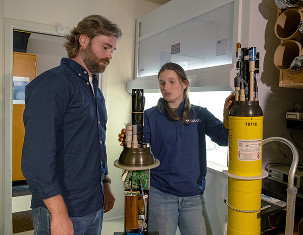
Answering such difficult questions about marine snow and ocean carbon transport involved an interdisciplinary team of MBARI scientists and engineers. Together, they created a device that can measure how much carbon is sinking into the deep sea, when, and how. SINKER—the SINKing Ecology Robot—features advanced cameras and microscopes to collect frequent real-time data about marine snow sinking to the seafloor in Monterey Bay.
As particles sink through a central collection tube, three cameras capture images to measure their sinking speed. After the particles land on a collection plate, two upward-facing cameras take photos so researchers can measure the size, shape, and composition of each individual particle. Every two hours, a brush wipes off the imaging plate to keep it from being completely clogged with too many particles.
SINKER allows researchers to observe the biology of marine snow by logging thousands of snapshots of tiny organic particles sinking to the deep seafloor over the course of months, and eventually years. The instrument has a continuous power and data connection to shore via MBARI’s cabled ocean observatory. Advanced AI algorithms help researchers catalog observations from SINKER’s cameras.
MBARI researchers hope that this instrument will improve our understanding of carbon storage in the deep sea and how this process might be changing.
Turning to space for a global perspective
Direct measurements of carbon export are scarce, so scientists have to rely on models and satellite data to understand large-scale patterns in the ocean-carbon connection. Tiny plant-like phytoplankton in the ocean’s surface waters convert carbon dioxide into organic carbon via photosynthesis. Scientists can use satellite ocean color data to estimate phytoplankton communities and productivity.
The Carbon Flux Ecology Team and an interdisciplinary team of collaborators conducted a comprehensive analysis of the ecological mechanisms that drive the transport of carbon into the deep sea.

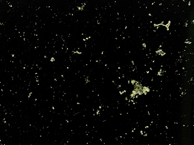
As part of the EXPORTS field campaign, researchers deployed sediment traps to collect particles of marine snow for further study in the laboratory. Image courtesy of Colleen Durkin
Supported by NASA’s interdisciplinary EXport Processes in the Ocean from RemoTe Sensing (EXPORTS) field campaign, the team sequenced DNA from 800 individual particles of marine snow and identified two groups of plankton—diatoms and photosynthetic Hacrobia—that can be used to predict the magnitude of carbon transport from the atmosphere to the deep sea.
New ocean color satellites, like NASA’s PACE (Plankton, Aerosol, Cloud, ocean Ecosystem) mission, are equipped with a hyperspectral Ocean Color Instrument—a radiometer that allows scientists to quantify the pigments in different taxonomic groups of phytoplankton in the surface ocean. Scientists can now look for blooms of diatoms and Hacrobia, specifically, to develop better models that estimate carbon export to the ocean's depths at a global scale.
The team developed a predictive model for ocean carbon export that links surface ocean phytoplankton communities with the ecological mechanisms that occur in the deep ocean. This groundbreaking work sets the stage for improving satellite-based models of ocean carbon export, which, in turn, will allow scientists to better predict the impacts of climate change and evaluate the effectiveness of future ocean-based climate interventions.
Existing satellite-based models often do not capture what happens below the ocean’s surface, a challenge MBARI’s Data Integration and Interdisciplinary Oceanography Team has been working to address.
The team is particularly interested in addressing which processes drive patterns of biological communities throughout the water column over time. These relationships are especially challenging to decipher because they are not always direct. For example, because plankton are displaced by currents, what we observe in one location may be the result of past conditions tens of kilometers away. The Data Integration and Interdisciplinary Oceanography Team develops models to untangle these effects, identify which processes drive biological communities, describe how they occur, and quantify their impact.
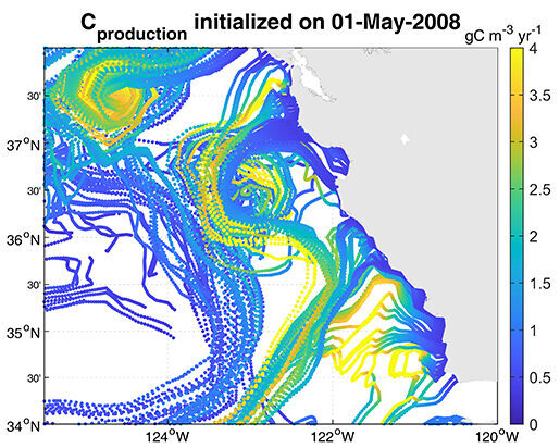
MBARI has deployed a suite of advanced technologies to monitor the abyssal seafloor offshore of Central California and understand how carbon is cycled from the surface to the deep sea.
MBARI researchers and collaborators had previously observed pulses of carbon to the deep seafloor that could not be explained by existing satellite-based algorithms of carbon export. Those algorithms model ocean physics and biogeochemistry, but do not consider the lag in both time and space between phytoplankton productivity at the surface and carbon export to the deep sea. The Data Integration and Interdisciplinary Oceanography Team developed a new Lagrangian growth-advection satellite-derived model that maps plankton succession and export onto surface oceanic circulation following coastal upwelling.
Originally designed to track biological hotspots where marine life congregates, this new approach incorporates the offsets between production and export, the role of zooplankton, and advection of plankton blooms by ocean currents. This method performed as well as models that rely on ocean color or long-term monitoring of carbon raining down on the abyssal seafloor.
The team’s success demonstrates that export can be well represented from space without ocean color, using a plankton model and satellite-derived tracks of oceanic currents. Importantly, this work suggests that carbon export may be more variable than previously recognized when inferred from ocean color alone, a finding that helps explain the deep-sea carbon pulses observed at a long-term MBARI research site on the abyssal seafloor off of California.
Understanding a changing ocean
Ocean observations and models suggest that marine heatwaves have been expanding in size and intensifying over the past few decades. The ocean absorbs a quarter of the carbon dioxide emitted each year, thanks to the steady stream of carbon particles sinking from the surface to the deep sea.
The ocean has a biological carbon pump, powered by plankton, bacteria, and other microscopic organisms that form the base of the ocean food web, which normally acts like a conveyor belt carrying carbon from the surface to the deep ocean. As climate change further alters ocean environments, researchers are working to understand the complex effects that ripple across marine ecosystems.
MBARI scientists and an interdisciplinary team of collaborators learned that marine heatwaves can reshape ocean food webs, which in turn can slow the transport of carbon to the deep sea and hamper the ocean’s ability to buffer against climate change.
The research team combined multiple datasets that tracked biological conditions in the water column in the Gulf of Alaska for more than a decade. This region experienced two successive marine heatwaves during this time, one from 2013 to 2015 known as “The Blob,” and another from 2019 to 2020.
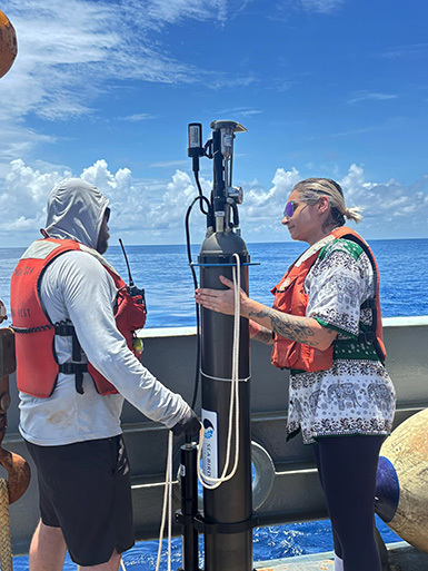
The team used information collected by the Global Ocean Biogeochemical (GO-BGC) Array, a collaborative initiative funded by the US National Science Foundation and led by MBARI that uses robotic floats to monitor ocean health. The GO-BGC project has deployed hundreds of autonomous biogeochemical Argo (BGC-Argo) floats, which assess ocean conditions such as temperature, salinity, nitrate, oxygen, chlorophyll, pH, and particulate organic carbon (POC) up and down the water column every five to 10 days. The team also looked at seasonal data from long-running ship-based surveys that tracked plankton community composition.
Under typical conditions, phytoplankton convert carbon dioxide to organic material. These microorganisms are the foundation of the ocean food web. When they are eaten by larger animals and excreted as waste, they transform into organic carbon particles that sink from the surface through the ocean’s mesopelagic, or twilight, zone (200 to 1,000 meters, approximately 660 to 3,300 feet) and down to the deep sea. This process locks atmospheric carbon away in the ocean for thousands of years.
However, the two major marine heatwaves in 2013–2015 and 2019–2020 altered plankton communities and disrupted the ocean’s biological carbon pump. The conveyor belt carrying carbon from the surface to the deep sea jammed, increasing the risk that carbon can return to the atmosphere instead of being locked away deep in the ocean.
A warmer ocean can mean less carbon locked away, which in turn can accelerate climate change. Beyond the changes to carbon transport, the shifts in the phytoplankton community at the foundation of the ocean food web have cascading impacts on marine life and human industry too.
The same robotic float technology revealing the impacts of marine heatwaves in the Northeastern Pacific is providing fundamental insight into biogeochemical processes in the most remote region on Earth.
Encircling Antarctica, the Southern Ocean plays an outsized role in global climate. It covers about a third of the global ocean’s surface area but accounts for a much larger share of oceanic carbon uptake. But harsh weather, sea ice, and sheer remoteness make it one of the most difficult systems to observe directly.
The Southern Ocean Carbon and Climate Observations and Modeling (SOCCOM) project—an international collaboration hosted by Scripps Institution of Oceanography—has released more than 300 robotic profiling floats into the Southern Ocean. These floats surface every 10 days on average and transmit satellite data on ocean conditions, including chemistry and productivity.
MBARI has been instrumental in developing and refining the chemical sensors that make these measurements possible. These floats are our eyes and ears in a part of the ocean where shipboard measurements are sparse. They give scientists year-round, basin-wide coverage that was unimaginable a decade ago.
Combining a massive trove of data from these floats with cutting-edge machine learning, SOCCOM researchers at MBARI and their collaborators found the ocean’s ability to store atmospheric carbon is even greater—and growing faster—than previously thought.
Annual net community production (ANCP)—a measure of how much carbon is converted into organic matter and exported to depth—in the Southern Ocean increased by nearly one percent per year between 2004 and 2022. On average, this region exports 3.91 billion metric tons of carbon each year. The research suggests that traditional methods for estimating ANCP from seasonal nitrate changes may underestimate true carbon export by roughly one-third.

The GO-BGC project has deployed hundreds of robotic floats to assess and track ocean health. Data from these floats help scientists understand how climate change affects marine life and ecosystems. Image: Jared Figurski © 2022 MBARI
The ocean plays an integral role in Earth’s climate. Sustained, long-term ocean monitoring projects like GO-BGC and SOCCOM are essential for understanding the complex connections between our ocean and our changing climate. MBARI research and technology play a critical role in these global initiatives. By sharing our data and expertise with resource managers and policymakers, we hope to guide decision-making about the future of the ocean.
Research Publications:
Amaral, V.J. and C.A. Durkin. 2025. A computer vision-based approach for estimating carbon fluxes from sinking particles in the ocean. Limnology and Oceanography: Methods, 23(2): 117–130. https://doi.org/10.1002/lom3.10665
Bif, M.B., C.T.E. Kellogg, Y. Huang, J. Anstett, S. Traving, M.A. Peña, S.J. Hallam, and K.S. Johnson. 2025. Marine heatwaves modulate food webs and carbon transport processes. Nature Communications, 16: 8535. https://www.nature.com/articles/s41467-025-63605-w
Bodel, A., M. Estapa, and C.A. Durkin. 2025. Solitary phytoplankton cells sink in the mesopelagic ocean. PLOS One, 20(7): e0321918. https://doi.org/10.1371/journal.pone.0321918
Durkin, C.A. 2025. The biology of marine snowflakes. Annual Review of Marine Science, 18. https://doi.org/10.1146/annurev-marine-040523-021832
Kramer, S.J., E.L. Jones, M.L. Estapa, N.L. Paul, T.A. Rynearson, A.E. Santoro, S. Sudek, and C.A. Durkin. 2025. Sinking particles exporting diatoms and Hacrobia predict the magnitude of oceanic POC flux. The ISME Journal, 19(1): wraf105. https://doi.org/10.1093/ismejo/wraf105
Liniger, G., J.D. Sharp, Y. Takeshita, and K.S. Johnson. 2025. Two decades of increase in Southern Ocean net community production revealed by BGC-Argo Floats. Global Biogeochemical Cycles, 39(8): e2024GB008371. https://doi.org/10.1029/2024GB008371
Liniger, G., S. Moreau, D. Lannuzel, M.M. Carranza, and P.G. Strutton. 2025. Southern Ocean carbon export revealed by backscatter and oxygen measurements from BGC-Argo Floats. Global Biogeochemical Cycles, 39(4). https://doi.org/10.1029/2024GB008193
Messié, M., C.L. Huffard, M.R. Stukel, and H.A. Ruhl. 2025. Spatial and temporal interplay between oceanic circulation and biological production in shaping carbon export off the California coast. Geophysical Research Letters, 52(7): e2024GL113707. https://doi.org/10.1029/2024GL113707