2023 Annual Report
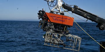
An MBARI remotely operated vehicle outfitted with a silver seafloor mapping toolsled. The robotic submersible has a bright orange float with the name “Ventana” with MBARI’s gulper eel logo serving as the “V.” Beneath the float is a black metal frame and various pieces of equipment and wires. The toolsled has a silver frame that extends past the back of the submersible. The submersible was photographed during recovery, attached to a black-and-white crane and positioned over the side of a research ship with dark blue water below and clear blue sky in the background. Four members of the ship crew are standing on the gray deck of the ship. Two are wearing bright orange life vests and white hard hats while managing the bright yellow tether connected to the submersible. One is wearing a bright orange jacket and spooling the tether. The fourth is wearing a bright orange jacket and holding a portable set of submersible controls.

The Low-Altitude Survey System (LASS) is a custom-built sensor suite that visualizes the deep seafloor in centimeter-scale detail. Currently deployed using MBARI’s remotely operated vehicles, MBARI engineers are working to transition this instrument to autonomous platforms. Image: Dave Caress © 2023 MBARI

Transforming our understanding of the deep seafloor with new technology

Hidden beneath the ocean’s surface lies complex terrain—expansive plains, towering seamounts, deep canyons, and chasm-like trenches. Imaging the structure of the ocean floor is critical to understanding the biology and ecology of the largest living space on our planet. But to date, only about 25 percent of the seafloor has been mapped at a resolution useful for scientific study.

New tools and techniques are needed to reveal seafloor geology and biology over large areas, particularly in rugged terrain and areas of societal and ecological significance. MBARI engineers have developed new instrumentation to conduct efficient, high-resolution, and repeatable surveys of deep-sea research sites.

An MBARI remotely operated vehicle outfitted with the silver seafloor mapping toolsled. The toolsled has a metal frame with a black cylinder at the center pointed downward. The robotic submersible has a black camera, a black metal manipulator arm, a black metal frame, a bright yellow float, and several colored wires. Photographed during deployment, the submersible is attached to a white crane and dangling over an open moon pool with light blue-green water below. Two marine operations staff supervise the launch, one in a white t-shirt and gray headset and the second in a navy shirt, orange life vest, and gray headset.
By outfitting the remotely operated vehicle (ROV) Doc Ricketts with the innovative Low-Altitude Survey System (LASS), MBARI researchers were able to visualize the floor of Monterey Canyon in centimeter-scale detail. Image: Dave Caress © MBARI

MBARI’s custom-designed Low-Altitude Survey System (LASS) combines multibeam (sonar) bathymetry, lidar (laser) bathymetry, and stereo photography to visualize the seafloor in remarkable clarity. This sensor suite can image geological and biological features of the ocean floor to centimeter-scale resolution.

MBARI's efforts to develop seafloor mapping technology began nearly 20 years ago. In 2006, MBARI started using Dorado-class autonomous underwater vehicles (AUVs) to map the ocean floor to one-meter (3.3-feet) resolution. In 2011, MBARI began using remotely operated vehicles (ROVs) as platforms for high-resolution low-altitude surveys of the seafloor with the LASS.

As the ROV transits three meters (10 feet) above the seafloor, lasers and sonar scan a six-meter (20-feet) wide swath of the bottom. The sonar measures the topography of the hard seabed, including rocks and sediments. The lasers record any three-dimensional object below the ROV, including living animals with soft tissues. High-resolution photographs captured during the survey can then be draped onto the bathymetry data to create a realistic image of the seafloor. All of the survey sensors tilt automatically as the sled moves forward in order to more closely follow the contours of the seafloor. These incredibly detailed surveys can quantify the impact of the geological, geochemical, and biological processes that modify the seafloor at fine scales.

MBARI’s Seafloor Mapping Lab has used the LASS toolsled to map a variety of seafloor features and habitats at centimeter scale, including methane gas seeps, faults, deep-sea coral and sponge communities, and hydrothermal vents.

“Thanks to MBARI’s engineering innovation, we now have the tools to map the deep seafloor in unprecedented detail, providing insight into the ecology and geology of this environment.”
—Principal Engineer Dave Caress
A photomosaic assembled from photos taken during a low-altitude survey with an underwater robot. Dozens of pale octopus are visible nesting in two crevices along the black, rocky seafloor at the top left and the right of the photo. Other marine life, including pale orange sea anemones, are also visible. At the bottom left is a white scale bar labeled “1 meter” and “(3.3 feet)”.
Visual surveys of the center of the Octopus Garden revealed nearly 6,000 nesting pearl octopus (Muusoctopus robustus). Researchers estimate there may be more than 20,000 total nests at the site. Image: © 2021 MBARI

The LASS maps seafloor environments at the scale of the community of life that thrives there, making it particularly useful for ecological studies. MBARI engineers successfully deployed the ROV Doc Ricketts with the LASS to study the spectacular Octopus Garden, an octopus nursery located 3,200 meters (10,500 feet, or about two miles) below the ocean’s surface near the base of Davidson Seamount, offshore of Central California.

The LASS gathered detailed bathymetry information to help researchers characterize the seafloor at this essential habitat. The LASS also took high-resolution photographs of the Octopus Garden. Researchers assembled these photographs into a photomosaic to quantify the number of nests at this site. They documented 5,718 octopus within a 2.5-hectare (6.2-acre) area at the center of the Octopus Garden. The team estimated the total population of the 333-hectare (823-acre) hillock could easily exceed 20,000 individuals. The Octopus Garden is the largest known aggregation of octopus anywhere in the world. At this nursery, warmth from deep-sea thermal springs accelerates the development of octopus eggs. Scientists believe the shorter brooding period increases survival odds for the vulnerable hatchlings.

The LASS suite has also helped MBARI researchers better understand the processes that sculpt submarine canyons.

Deep below Monterey Bay lies one of the largest submarine canyons on the west coast of North America. Monterey Canyon has a topography that rivals the Grand Canyon, but its scale and grandeur remain out of sight beneath the waves. Repeated efforts at MBARI to map and monitor this submarine canyon have revealed a surprisingly active seabed. Frequent landslides tumble through the canyon and affect the community of life on its rocky walls and sediment-covered floor.

From 2015 to 2017, MBARI’s Coordinated Canyon Experiment aimed to monitor the passage of sediment gravity flows—underwater landslides known as turbidity currents—at multiple locations in the canyon simultaneously. Understanding the complex geological processes that shape Monterey Canyon can help us better understand how submarine canyons might be tied to coastal geohazards, like local tsunamis, or risks to underwater telecommunications infrastructure.

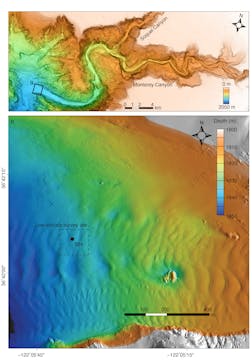
A map of Monterey Canyon (top, labeled A) and a detailed map of study site (bottom, labeled B).   The map labeled A shows the continental shelf in pale orange and twists and turns of Monterey Canyon in a gradient of orange, yellow, green, blue, and purple. The canyon starts at orange to the right, with its deepest reaches on the left represented in purple. A label for “Soquel Canyon” is below a branch of the canyon and a label for “Monterey Canyon” is below the main canyon channel. On the left side is a black box labeled “B.” On the bottom is a black-and-white striped scale bar marked with 0, 1, 2, and 4 kilometers. To the top right is a compass with four points with “N” marking north and pointed diagonally to the right. To the bottom right is a depth legend with a rectangle with a gradient of white, orange, yellow, green, blue, and purple that represents 0 meters (top) and 2,050 meters (bottom).  The map labeled B shows a detailed section of the Monterey Canyon map above. This map shows a depth gradient—represented right to left (shallow to deep) by shifting colors from orange to yellow to green to blue—and the rippled texture of the seafloor. A box with dashed black lines is labeled “Low-altitude survey site” and contains a single small black dot that reads “SIN” denoting the location of the Seafloor Instrument Node. On the bottom is a black-and-white-striped scale bar marked with 0, 100, 200, and 400 meters. At the top right are a compass with four points with “N” marking north directly above and a depth legend with a rectangle with a gradient of white, orange, yellow, green, blue, and purple and notches marking 1,800, 1,810, 1,820, 1,830, 1,840, and 1,850 meters. Outside the map are labels for latitude on the left (36°42’00’’ and 36°42’15’’) and longitude (-122°05’45’’ and -122°05’15’’).

Monterey Canyon (A) is located just offshore of MBARI’s research facilities in Moss Landing, California. MBARI researchers conducted high-resolution, low-altitude surveys in a part of the canyon floor 50 kilometers (31 miles) from the canyon head (B) and deployed the Seafloor Instrument Node (SIN) to monitor environmental conditions, like currents, at the site to shed new light on processes that sculpt submarine canyons. Image: Monica Wolfson-Schwehr © 2023 MBARI
As part of the Coordinated Canyon Experiment, a team of researchers from MBARI, USGS, Durham University, the University of Hull, and Pontificia Universidad Católica de Chile conducted repeated surveys of a site in Monterey Canyon with an early model of the LASS sensor suite on the ROV Doc Ricketts to investigate the ongoing processes that carve the canyon.

Pairing repeated surveys of the canyon floor with water current monitoring and sediment sampling provided researchers with a more complete picture of activity in Monterey Canyon. Surprisingly, the daily movement of tides oscillating up and down the canyon plays a major role in shaping the structure of the seabed.

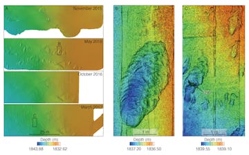
A series of bathymetry maps.   To the left, four maps labeled A represent a location surveyed in November 2015, May 2016, October 2016, and March 2017 by sonar. The maps show a depth gradient, represented right to left by shifting colors from orange to yellow to green to blue. A black box on the second map is labeled B and a black box on the fourth map is labeled C. A black scale bar at the bottom represents 25 meters. A legend reads “Depth (m)” and shows the color gradient from orange and -1833 on the right to blue and -1844 on the left.  The center map labeled B represents a scrape on the seafloor surveyed by lidar in May 2016. The map shows a depth gradient, represented from right to left by shifting colors from orange to yellow to green to blue. A scour (scrape) that developed on the seafloor in the bottom two-thirds of the map is blue with a green edge. A black scale bar at the bottom represents one meter. A legend reads “Depth (m)” and shows the color gradient from orange and -1836.5 on the right to blue and -1837.2 on the left.  The right map labeled C represents a location on the seafloor surveyed by lidar in March 2017. The map shows a depth gradient, represented from right to left by shifting colors from orange to yellow to green to blue. The site has one large blue scour on the left, several smaller blue scours in the lower center, and two yellow mounds to the upper right. A black arrow labeled “crab” points to a green outline of a crab on the large blue scour. A black scale bar at the bottom represents one meter. A legend reads “Depth (m)” and shows the color gradient from orange and -1839.10 on the right to blue and -1839.55 on the left.

Four repeat surveys with MBARI’s LASS sensor suite between November 2015 and April 2017 provided an incredibly detailed view of changes to the floor of Monterey Canyon, including large migrating bedforms and smaller ripples and scours. The LASS combines various sensors, including sonar bathymetry (A) at a resolution of five centimeters (two inches) and lidar bathymetry (B and C) at a scale of one centimeter. Lidar data provide richer detail about the seafloor, revealing objects that are too small to be seen by sonar. Image: Monica Wolfson-Schwehr © 2023 MBARI
The amount of sediment moved by internal tides is too small to be detected by traditional ship-based instruments. The detailed data provided by MBARI’s LASS sensor suite meant researchers could finally take accurate measurements of the changes to the structure of the canyon floor due to tidal currents.

The team determined that the ebb and flow of the tides carved the meter-sized scours and centimeter-sized textures they observed on the seabed at the canyon’s axis. Previous mapping work in the area missed these features because the resolution—even with the meter-scale maps from MBARI’s own mapping vehicles—was too coarse. This work has provided vital context for understanding not only life on the ocean floor but also how underwater infrastructure that we depend on may be vulnerable to underwater landslides.

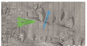
A grayscale image of seafloor texture. Scours in the sediment are outlined in black dashed lines. Three green arrows point to the left and represent the flow of turbidity currents with labels for January 15, 2016, September 1, 2016, and February 3, 2017. A blue arrow labeled “peak tides” points diagonally to the right and represents the movement of internal tides. A white scale bar at the bottom represents five meters.

Lidar technology on MBARI’s LASS sensor suite uses pulses of lasers to record the bathymetry, or underwater topography, on the seafloor at centimeter-scale resolution. Surveys with the LASS suite at a scour field 1,840 meters (6,037 feet) deep on the floor of Monterey Canyon revealed how turbidity currents (green) and tides (blue) affected the structure of the seafloor. Image: Monica Wolfson-Schwehr © 2016 MBARI
MBARI is continuing to develop and improve its seafloor mapping capability.

In October 2023, engineers from the Seafloor Mapping Lab and the Control, Modeling, and Perception of Autonomous Systems (CoMPAS) Laboratory deployed the ROV Ventana for a series of mapping surveys at Sponge Ridge, a rocky crest in Monterey Canyon, to test new software for the LASS. These surveys marked a historic milestone—the ROV Ventana's 4,500th dive for deep-sea science—and underscored the vehicle’s importance to MBARI as a platform for ocean engineering.

In its current configuration, the LASS executes a path programmed in advance, and then the engineers process the data to assemble a map. Engineers in the CoMPAS Lab have been developing a new software package that will allow the sensor suite to build a map in real time and use it to navigate the environment. This is a critical next step in efforts to integrate the mapping instrumentation on autonomous underwater vehicles.

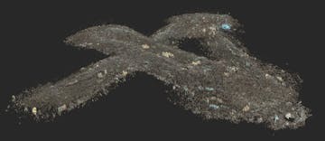
A three-dimensional visualization of the seafloor created during a test of a new software package. This screenshot shows data from two diagonal paths and one intersecting vertical path forming an XI shape. The seafloor within the XI shape is represented as jagged brown pixels with patches of yellow, green, and blue pixels representing marine life, including fan-shaped corals and vase-like sponges. The data are plotted against a solid black background.

Engineers from MBARI’s CoMPAS Lab are developing a Simultaneous Localization and Mapping (SLAM) framework using the LASS to generate three-dimensional maps of the seafloor in real time. Image: © 2023 MBARI
Building on the success of the LASS, the Seafloor Mapping Lab is also collaborating with 3D at Depth to develop a next-generation underwater lidar system that can be integrated into autonomous platforms and enable further progress in efforts to map the deep ocean floor.

Lidar, or light detection and ranging, uses a laser to reconstruct three-dimensional terrain. Subsea lidar uses pulses of high-intensity green laser light to collect incredibly precise information about seafloor characteristics, allowing researchers to generate detailed bathymetric maps.

In 2013, MBARI began testing 3D at Depth’s technology with the first-generation subsea lidar system, the SL1. This sensor was incorporated into the LASS on MBARI’s ROV Doc Ricketts.

The SL1 was originally designed for surveying underwater infrastructure for the oil and gas industry. It projected a two-dimensional 30-degree by 30-degree field of view, which was ideal for detailed sideways scans of wellheads and pipelines. However, this narrow coverage meant that down-looking, “mow-the-lawn” surveys of the seafloor were very inefficient.

The seafloor mapping toolsled with a weathered metal frame, silver and black metal canisters, and a tangle of green, blue, and yellow cables. The toolsled was photographed while submerged in MBARI’s test tank and suspended by a yellow crane hook and red ropes as the lidar canister projects three green lasers toward the bottom of the tank. Three gray, concrete walls are
MBARI uses lidar technology from 3D at Depth to visualize the deep seafloor at high resolution. In 2024, MBARI and 3D at Depth will build and test a more portable lidar system for seafloor mapping. Image: Todd Walsh © 2018 MBARI

In 2015, MBARI and 3D at Depth began developing the first deep-ocean lidar optimized for seafloor mapping, named the Wide Swath Subsea LiDAR (WiSSL). In 2017, 3D at Depth delivered a WiSSL rated to 4,000 meters (13,100 feet) depth with a 90-degree field of view that covers a seafloor swath twice as wide as the distance to the seafloor.

After six years of successful operations with the WiSSL, the team now aims to build and test a next-generation WiSSL during 2024 that will cover a wider swath, be more portable, and draw less power. The lighter system will be well suited for autonomous platforms, bringing MBARI engineers closer to their vision of integrating the low-altitude survey capability on smaller AUVs to flexibly scale their seafloor mapping efforts.

The new system will open up further possibilities beyond mapping the seafloor. The next-generation WiSSL will have a 360-degree field of view and be able to conduct three-dimensional scans in open water, over complex terrain, and even on vertical terrain.

Repeated mapping of the deep seafloor is essential for understanding the complexity of its landscapes, the processes that create and disrupt them, and their functions as habitat. The health of the deep sea is critical to the health of our planet. Scientists are racing to understand the deep sea before it is forever altered by climate change, pollution, mining, and overfishing.

Support for this research was provided by the David and Lucile Packard Foundation and the Natural Environment Research Council of the United Kingdom (NE/K011480/1).


Research Publications:

Barry, J.P., S.Y. Litvin, A. DeVogelaere, D.W. Caress, C.F. Lovera, A.S. Kahn, E.J. Burton, C. King, J.B. Paduan, C.G. Wheat, F. Girard, S. Sudek, A.M. Hartwell, A.D. Sherman, P.R. McGill, A. Schnittger, J.R. Voight, and E.J. Martin. 2023. Abyssal hydrothermal springs – cryptic incubators for brooding octopus. Science Advances, 9: eadg324. doi.org/10.1126/sciadv.adg3247

Wolfson-Schwehr, M., C.K. Paull, D.W. Caress, R. Gwiazda, N.M. Nieminski, P.J. Talling, C. Carvajal, S. Simmons, and G. Troni. 2023. Time-lapse seafloor surveys reveal how turbidity currents and internal tides in Monterey Canyon interact with the seabed at centimeter-scale. Journal of Geophysical Research: Earth Surface. 128: e2022JF006705. doi.org/10.1029/2022JF006705

Expanding access to innovative MBARI technology

A new partnership with Saab, Inc. will make the MBARI long-range autonomous underwater vehicle commercially available for the first time.