Wonderland of spires and hydrothermal chimneys discovered

Advanced deep-sea mapping technology has enabled the discovery of hundreds of hydrothermal chimneys on the seafloor off the coast of Washington State. Researchers were amazed to find 572 chimneys, even though many of the structures were close to vent sites that had been studied for decades.

Marine geologists and biologists have used human-occupied submersibles and underwater robots to study vent fields on the Endeavour Segment of the Juan de Fuca Ridge for the last four decades. Endeavor is about 350 kilometers (220 miles) northwest of Washington State. Its vents are located in a narrow axial valley about 14 kilometers (8.6 miles) long and 1.5 kilometers (0.9 miles) wide.

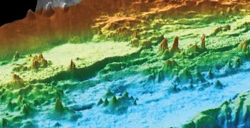
The Endeavour Segment of the Juan de Fuca Ridge is an active volcanic area far off the coast of the Pacific Northwest. Illustration: © MBARI

Early on, scientists discovered that the field was very active, with many vents and enormous chimneys, but none of these surveys had high enough resolution to detect individual chimneys over large areas of the seafloor. The area was also hard to access, so no one had ever mapped all the vents to determine how many existed.

It was not until MBARI’s autonomous underwater vehicle (AUV) D. Allan B. mapped the area at high resolution that geologists were able to see the plethora of spires and chimneys in the Endeavour area. The vehicle, which can detect features as small as 1.25-meters (four feet) across, was flown 50 meters (160 feet) above the rugged seafloor during seven surveys in 2008 and 2011. Overall, the AUV completed 140 hours of surveys and mapped about 62 square kilometers (24 square miles) of the seafloor.

“It’s very hard to see down there because all the particulates in the water create a kind of haze,” said David Clague, MBARI’s lead scientist on this research. “I remember there was one well-studied chimney where the composition of the fluids seemed to vary from one year to the next. It wasn’t until we did our detailed mapping that we realized they had actually been sampling two different chimneys. They apparently would encounter one chimney or the other depending on the direction they approached the site.”

MBARI’s mapping effort revealed many large and presumably active chimneys. The tallest is at least 27 meters (90 feet) high. But the majority of the chimneys were smaller—less than eight meters (26 feet) tall—and the researchers believe many are inactive, meaning they are no longer releasing fluids.

Tectonic forces are ripping apart the seafloor in the Juan de Fuca region. Magma beneath the seafloor heats water within the surrounding bedrock, which emerges from the seafloor in the form of underwater seeps and geysers known as hydrothermal vents. When this superheated, mineral-rich water comes in contact with near-freezing seawater, the dissolved minerals crystalize, creating the spires and hydrothermal chimneys that can grow to up to 27 meters (90 feet) tall.

Endeavour oblique view crop 828

The Endeavour Segment of the Juan de Fuca Ridge is an active volcanic area far off the coast of the Pacific Northwest. Illustration: © MBARI

Prior to the high-resolution mapping surveys, American and Canadian scientists had named about 47 active hydrothermal vents, most of which lie within five major vent fields. They also discovered that this region not only had vast numbers of chimneys but also had some of the tallest hydrothermal chimneys known on any mid-ocean ridge in the world. The tallest of these chimneys, which they named “Godzilla,” reached a height of 45 meters (150 feet) before it toppled over in 1995.

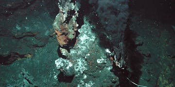
Active chimneys typically form where superheated water (over 300 degrees Celsius; 570 degrees Fahrenheit) flows up through cracks in the seafloor. If this flow is strong and lasts long enough, the chimney may grow taller and taller until it becomes unstable and topples over. However, many seafloor cracks and chimneys become clogged by mineral deposits. At this point, the chimney becomes inactive and stops growing but may remain standing for hundreds of years. Meanwhile, the fluids from the clogged chimney find their way upward through different cracks in the seafloor to form new chimneys nearby.

To figure out what makes the Endeavour Segment unique, the researchers compared the types of chimneys at Endeavour with those found at the Alarcón Rise (near the southern tip of Baja California in Mexico), another spreading center that MBARI has mapped in detail. They found that the Endeavour Segment had many more chimneys, but a lower proportion of active chimneys.
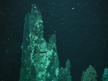
Chimney t467 DSCN4995

When superheated fluids stop flowing from a hydrothermal chimney, the chimney becomes inactive, but may remain standing for hundreds of years. Image: © MBARI

Clague and his coauthors suggest that the Endeavour Segment has lots of inactive chimneys because this area has had only a few small volcanic eruptions over the last several thousand years, and lava has not buried the chimneys. In contrast, at the Alarcón Rise, large amounts of lava have erupted from the seafloor, burying or destroying older chimneys, so only the youngest and most active chimneys remain.

Based on their work at Endeavour and other mid-ocean ridges, the researchers propose that these ridges may go through three phases of evolution:

  • A magmatic phase, lasting up to tens of thousands of years when large amounts of lava erupt and cover the seafloor.
  • A tectonic phase, lasting perhaps 5,000 years when the magma supply slows, and the seafloor cools and contracts while spreading continues. During this phase, the axial valley sinks, and numerous cracks and faults form in the seafloor.
  • A hydrothermal phase, lasting just a few thousand years, when resurgent magma below the surface heats fluids that percolate upwards through the abundant seafloor cracks and faults, forming large numbers of vents.
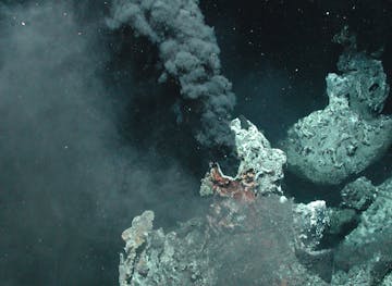
Endeavour smoker (hydrothermal vents)

Black smokers such as this one in the Endeavour vent field, belch superheated fluids at over 300 degrees Celsius (570 degrees Fahrenheit) into the surrounding seawater. Such active hydrothermal vents form chimneys that can grow to over 30 meters (100 feet) tall. Image: © MBARI

The researchers think that the Endeavour area has been in a hydrothermal phase for about the last 2,000 years. However, they suspect it may be entering a new magmatic phase, which means that the area could see more volcanic eruptions in the future. When this happens, many of the chimneys they mapped will be buried under new lava flows, and the fractured rocks that currently allow substantial amounts of fluid to rise to the surface will be mostly sealed.

Meanwhile, geologists studying the Endeavour Segment will be able to use MBARI’s new maps to plan future research dives and decide where to put monitoring equipment on the seafloor.

Data from MBARI’s mapping effort have also been used by collaborators at the University of Ottawa and GEOMAR, a German ocean research organization, to estimate the volume and mass of the hydrothermal deposits in the Endeavour chimneys. Although seafloor mining is unlikely within the Endeavour vent fields, because the Canadian government declared them part of a marine protected area, the estimates are critical for understanding the distribution of metal-rich rocks elsewhere at hydrothermal vents that could be targeted for mining.

MBARI has used mapping AUVs widely in the Pacific in recent years, enabling advances in many aspects of ocean science. High-resolution data collected with the vehicles have informed research on methane venting fields in the Arctic, unusual seafloor formations off of Taiwan, pockmarks and seafloor stability off the coast of California, hydrothermal vents in the Gulf of California off Mexico, rich sponge and coral communities on a California seamount, and episodic debris flows in Monterey Canyon. To accomplish these feats, Principal Engineer Dave Caress and AUV Group Leader Hans Thomas and their teams have conducted expeditions from the decks of not only MBARI-owned vessels but various research vessels of opportunity that had easier access to remote locations of interest.

Transforming data points into pixels

The seafloor mapping team joined forces with Frame 48 to create the highest-resolution animation of Monterey Canyon to date.