2019 Annual Report
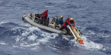
Aku Recovery Boat leg1 Hoffman

Photo by Thom Hoffman/courtesy of Schmidt Ocean Institute

Fleet of nimble vehicles provides range and agility to oceanographic research

The ocean presents marine scientists and engineers with the ultimate challenge—a constantly changing four-dimensional environment teeming with hard-to-track life. In 2003 and 2006, MBARI ran a multi-institutional field experiment using large ships, hefty autonomous vehicles, and a host of other equipment to measure changes over time and space in Monterey Bay. This initiative made headway, but certain tasks proved impossible given the limited speed and range of the equipment. The scientists and engineers needed higher performance underwater vehicles that could not only carry sophisticated scientific instruments but also operate with long-range capacity. Most importantly, the team needed vehicles powerful enough to outpace offshore currents and fast enough to effectively find and sample areas of interest in a timely fashion.

MBARI was in a unique position to fulfill this crucial need. Possessing both the technical expertise and willingness to take on a sophisticated, long-term development project, a team of engineers accepted the challenge and began developing a long-range autonomous underwater vehicle (LRAUV) system in 2007. The ultimate design of this innovative class of vehicles (called Tethys) evolved from a diverse set of requirements, including: 1) sufficient range to cross the California Current system with both basic and customized suites of oceanographic sensors and samplers; 2) the ability to stop and drift in the water column; 3) the ability to be operated to be run by a scientist and their technicians and lastly; 4) the vehicle must be economical.

By 2009, two of these Tethys-class AUVs were operational and had met all design requirements. Two science groups, under the leadership of Francisco Chavez and Chris Scholin, began using the LRAUV routinely as part of MBARI’s new Controlled, Agile, and Novel Observing Network (CANON) Initiative. CANON is an ongoing, interdisciplinary effort that collects oceanographic information using a fleet of smart, autonomous devices that are able to cooperate with each other.

The engineering team then turned its focus toward new payload options for the LRAUV. New nose sections have been developed for water sampling, measuring turbulence and bioluminescence, performing bioacoustics and line-capture docking, and creating a Wave Glider tow module. The most ambitious addition has been equipping the LRAUV with a third-generation Environmental Sample Processor (3G ESP). The new 3G ESP-equipped LRAUV was an especially potent combination for investigating the microbial world at the base of the ocean food web and harmful algal blooms.

Onboard autonomy to detect and follow ocean features—like subsurface layers of plants and animals—is paired with the ability to stop, hover, and drift in the water column to observe open-ocean ecosystems continuously for many days. The 3G ESP uses a filtration system to concentrate particles from a liter or more of seawater. It then applies a preservative to that material to capture a snapshot of gene expression and community composition at that moment. A series of up to 60 samples can be collected over many days to detect microbial community composition and gene expression; the presence of larger animals can also be revealed based on traces of DNA in a patch of water.

Another important feature of the 3G ESP LRAUV pairing is the ability to operate multiple vehicles together. For example, while one 3G ESP LRAUV follows a specific feature, like a patch of high chlorophyll, a second vehicle can use inter-vehicle communication and ranging to navigate around the first and collect contextual environmental information from the surrounding water. The two-vehicle combination allows scientists to decipher how the samples collected fit into a much larger context, such as how the patch of water evolves over space and time with respect to temperature, salinity, oxygen, chlorophyll, or frontal boundaries. By employing LRAUVs with additional complementary payloads, scientists can now simultaneously examine additional parameters, such as bioluminescence and fish abundance, with respect to the targeted 3G ESP samples.

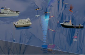
LRAUV CANON framegrab2

Three LRAUVs fly around and through an acoustic signal, detecting migrating animals as part of the CANON field experiment. Illustration by David Fierstein.

New analytical modules within the 3G ESP are currently under development to analyze the samples immediately after collection, in situ, to identify target genes or compounds of interest. One useful application of this emerging capability is to use the LRAUV to find hot spots of chlorophyll, follow and monitor those hot spots for the presence of specific harmful algal species and the toxins they produce, and to relay that information to shore.

As the LRAUV and its sensor payloads mature, MBARI’s scientists and engineers are beginning to export the technology and operational know-how to address a wider array of issues. The first step in that export has been through strategic partnerships with a range of agencies, including the National Science Foundation (NSF), the National Oceanic and Atmospheric Administration (NOAA), the US Geological Survey (USGS), the US Coast Guard (USCG), the Gordon and Betty Moore Foundation, and the Schmidt Ocean Institute.

LRAUVs have been used for NOAA experiments in Southern California, Monterey Bay, and Lake Erie, as well as USGS surveys in Lake Michigan. NSF funded the construction of three 3G ESP/LRAUVs for use by the University of Hawaii and the Schmidt Ocean Institute to study microbial communities in the open sea. The Moore Foundation is currently supporting the development of a new LRAUV payload to help quantify carbon flux export into the deep sea, while the USCG is developing an oil-spill response capability for the Arctic based on the same vehicle with a different sensor suite. The latter involves developing new payloads and software for operating under ice via a partnership with the Arctic Domain Awareness Center at the University of Alaska and the Woods Hole Oceanographic Institution, which has licensed and is now building LRAUVs for the US Coast Guard with funding from the DHS Science and Technology Directorate. The next step in exporting this technology will be to find a suitable partner to build, market, and distribute the vehicles to a growing list of interested end-users.
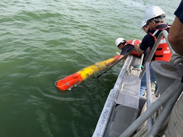
Lake erie 2019 deploy

MBARI and NOAA researchers launch an LRAUV containing an ESP to study harmful algal blooms in Lake Erie. Photo by Jim Birch.

Currently about half of the science groups at MBARI operate LRAUVs. A fleet of seven vehicles with different sensor/sampler configurations has been transitioned to the Division of Marine Operations for routine use. The LRAUV engineering team is improving the user interface making it more accessible to a wider range of users, enhancing onboard signal processing with advanced machine learning techniques to minimize the need for shoreside staff to guide operations.

Before the dream of having many teams of robots operating offshore simultaneously can be realized, the shoreside workload needs to be minimized so the operators can get back to their regular tasks and let the robots do most of the work. Achieving that dream points to a need to better understand human/robotic interaction and take advantage of next-generation computing/artificial intelligence developments.

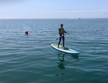
Brian Paddleboard

MBARI teamed up with Woods Hole Oceanographic Institution to develop a vehicle for under-ice oil spill mapping. In Santa Barbara, engineers took advantage of the presence of oil without the ice. They used human power to launch and recover the LRAUVs and successfully completed 10 days of LRAUV operations without involving any motorized boats; paddleboards and kayaks were pivotal to the operation.

MBARI engineers are also working to extend the endurance of the LRAUVs so they can spend more time offshore and underwater. By traveling slowly or drifting when possible, the duration of LRAUV’s missions can be extended to over a month. Once on station, the higher-power science payloads and computers can be switched on and off as needed to manage battery usage. The challenges of being power-limited have compelled the engineers to look at ways the LRAUV could be recharged at the worksite, far from home and without a human presence.

MBARI’s Wave Energy Extraction System is one way to solve the problem of limited power. Alternatively, a large battery pack, or fuel-powered generator on a surface vehicle, could supply the needed energy. But the trick is to develop a method to transfer the energy to the AUVs—yet another engineering hurdle.

At the beginning of the LRAUV story some 13 years ago, MBARI had just demonstrated an AUV docking station equipped with battery recharging. That system was a large, stationary seafloor-mounted system, providing an option for nearshore work. But as the need for AUVs to work far from land in very deep water grows, the challenge before the engineering team is to develop an AUV docking and charging system for the open ocean—and to integrate this onto an appropriate, unmanned surface-support platform.

The ongoing development and use of the LRAUVs showcase MBARI’s ability to take on high-risk, high-reward projects that would be difficult to tackle at other non-profit oceanographic institutions. It also serves as a shining example of what is possible when MBARI’s scientists and engineers work collaboratively as David Packard envisioned.

A robot that can follow animals in the deep sea

A new type of vehicle tracks small, deep-sea animals as they swim or drift through the water.