2019 Annual Report
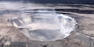
Halemaumau crater 6 5 19 usgs

Image courtesy of U.S. Geological Survey

The birth of a Hawaiian island

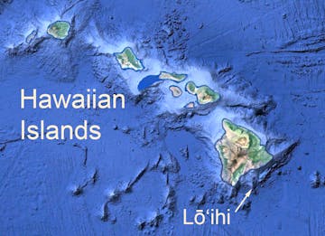
One hundred thousand years from now, Hawaii’s youngest volcanic island will puncture the surface of the North Pacific Ocean. This baby volcano—known as Loihi—is currently growing 1,000 meters (about 3,300 feet) below the ocean surface at the southeastern end of the Hawaiian Islands and will be the next addition to the 8,000-kilometer-long (5,000-mile-long) volcanic island chain.

Hawaiian island basemap

Loihi is an underwater volcano southeast of the Hawaiian Islands. It could reach the surface in 100,000 years. Base map by Google Earth.
Drawing on bathymetric data from three different surveys conducted over the last 25 years, MBARI researchers recently created a new map of Loihi. Because data from the three surveys were very “messy,” researchers from various institutes had been unable to make maps from these data sets. But MBARI researchers figured out how to put the data back together using MB-System, a seafloor mapping software that allows researchers to adjust for navigation errors and remove redundancies in the data.

The resulting high-resolution map of Loihi’s summit reveals details of several summit calderas (large oval depressions). These calderas formed as Loihi erupted, emptying lava chambers one to two kilometers below the seafloor and causing the seafloor to collapse. Where multiple calderas overlap, geologists can determine the eruption history of the volcano.

Similar calderas formed on Kilauea during the devastating 2018 eruption. Mapping these collapse events will help researchers better understand the life stages of Loihi, Kilauea, and other active Hawaiian volcanoes. This could help geologists prepare for future eruptions.

30 years of research on the abyssal plain provides clues to climate change

Unique deep-sea site reveals the transport of organic carbon from the surface to the seafloor and how it affects abyssal life.