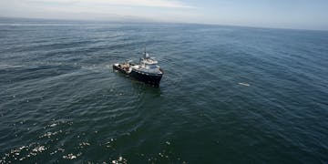
A suite of robotic seafloor surveying and sampling tools developed at MBARI over the last two decades has made it possible to document the passage of high-energy, avalanche-like, submarine sediment flows. Working with the US Geological Survey, MBARI is now planning to apply that equipment and know-how during scientific cruises that will explore, map, and sample submarine canyons crossing the lower slope of the Cascadia Subduction Zone in the Pacific Northwest. These expeditions are part of a concerted effort to advance the understanding of the recent tectonic deformation, submarine canyon sediment flows, and earthquake history along the Pacific continental margin.

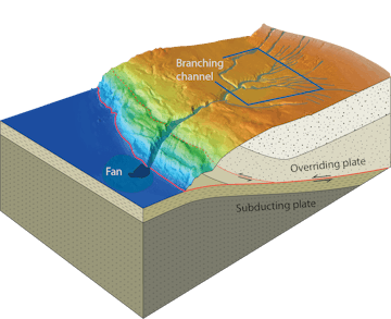
Three-dimensional perspective view of Trinidad Canyon’s bathymetry, with schematic drawing of the underlying structure along the Cascadia Subduction Zone. Illustration by Eve Lundsten.

Paleo-seismologists recently reported that earthquake-triggered tsunamis higher than 10 meters (33 feet) left deposits in lagoons along the coast of the Pacific Northwest multiple times over the last few thousand years. The last tsunami can be accurately dated because historical records from Japan show it crossed the Pacific and destroyed several Japanese villages on January 26, 1700.
These tsunamis were generated by mega-earthquakes (magnitude eight or greater) that occurred along the fault separating the subducting Pacific plate from the overriding North American plate along the entire Cascadia Subduction Zone. Increased recognition of the hazards such tsunamis pose to coastal areas in the Pacific Northwest highlights the importance and urgency of understanding mega-earthquake occurrence intervals.
The history of large earthquakes can also be reconstructed from the sedimentary evidence they leave and the seafloor deformation the faults produce. Earthquakes destabilize the overlying seafloor and produce avalanche-like submarine gravity flows. Such flows funnel into submarine canyons and move simultaneously downslope across the entire margin, eroding and depositing material as they go before ultimately leaving a fan of sediment on the subducting oceanic plate.
Interpreting the record of sediment flow deposits requires distinguishing deposits left by earthquake-triggered flows from those of non-earthquake-triggered flows. When looking at the branching and neighboring canyon systems in this area, it will be particularly important to determine if flow-derived sediment layers were deposited synchronously—suggesting earthquake-triggered flows. The relationship between the earthquake deformation documented in the detailed mapping surveys, the character of the sediment deposits that cover them, and the timing and age of those deposits all promise to reveal an independent record of recent large earthquakes. These efforts may provide critical information for regional hazard assessment.
